We are definitely in the midst of the hiking off-season, when high-elevation treks are generally impossible without ice axes and crampons. Since we have also had a very dry run in California, though, I thought it might be worthwhile to see if there were any modest peaks that might be possible to bag (without technical equipment) in preparation for our Kilimanjaro climb next month.
Enter Mt. Eddy, the highest peak of the Trinity Mountains in the Klamath range. This mountain is typically ignored in favor of its more famous (and impressive) neighbors, Mt. Shasta (the highest peak in the California portion of the Cascade range) and Mt. Lassen (the first peak over 10,000 feet that Mr. Petite Peaker and I bagged!), but at 9,025 feet, I thought it just might be doable in the (as-of-yet) drought conditions of this winter.
I found relatively little information about the Eddy hike online, and nothing about current conditions. Calls to
Shasta-Trinity National Forest went unanswered. The
Wikipedia entry for Eddy mentions "heavy snowfall," but when I researched the
Mt. Shasta Ski Park, I found that it is currently closed due to lack of snow. So we packed our day packs in hopeful anticipation of a ten-mile hike and started our four-hour drive at 5:00 AM.
 |
| I pulled to the side of the road while on I-5 at dawn to capture the sky and the incredible formations of the migrating Canadian geese. |
To reach the trailhead from I-5N (we were traveling from the San Francisco area), exit Edgewood-Gazelle (exit 751) and turn left onto Stewart Springs Road. The road was a little bit icy, but it was nothing compared to the ice and slush that awaited after we turned right onto Forest Road 17. (This is the road we were trying to contact the National Forest about; it can be closed in the winter due to icy or snowy conditions and such a closure would have made our trek impossible.) Continue uphill on this road for about ten miles to the trailhead.
At the trailhead, a Pacific Crest Trail (PCT) sign marks the trail, though there is no mention of Mt. Eddy. Head toward Dead Fall Lakes.
 |
| The easy first portion of the trail, headed toward Dead Fall Lakes. |
The trail was an easy three miles to the first of the lakes, which was completely frozen and looked great for ice skating. We ran into three couples who were doing a loop around the lake; they then headed back and we ran into no one else on our way to the summit or on our return trip.
After passing by two more lakes (also frozen) higher up and several icy/snowy patches, we came across the summit trail junction (the first mention of Mt. Eddy) and made our final ascent. If I were to label the first three miles of this hike as "easy," I would categorize the remaining two to the summit as "moderately difficult," though I may have felt differently if there were no ice. There are frustrating switchbacks at the end, at a point where it looks like you could just jog straight up to the summit - but it's steeper than it looks, and I have no doubt that the switchbacks are helpful.
 |
| Mr. Petite Peaker throwing stones on the second frozen lake; yes, it's really solid! |
 |
| The third and final frozen lake we encountered, with the summit in view. |
 |
| Don't get discouraged at this point; though the summit looks to be a long way, it's less than two miles from here. |
 |
| The first mention of Mt. Eddy. Shortly after this point, you'll reach the switchbacks of the final stretch. |
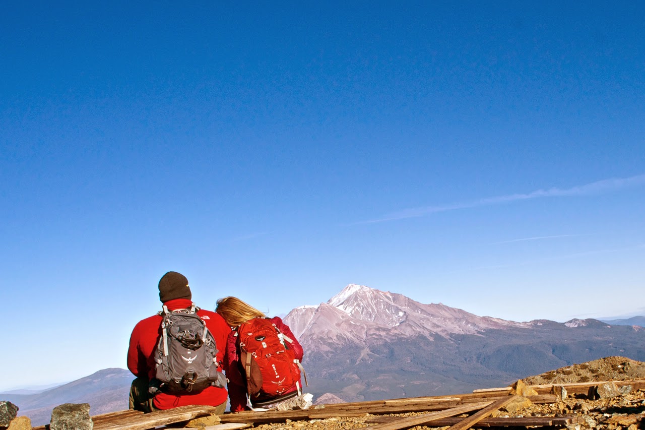
The summit of Mt. Eddy was cold and windy, but snow free. (Snow could be seen on other parts of the summit ridge.) The view of Mt. Shasta was absolutely stunning, perhaps even more so because you don't get this view from the trail at all - you have to set foot on the summit for the tremendous payoff.
 |
| With our backs to Mt. Shasta, looking out at the ridge from the summit of Mt. Eddy. |
 |
| That view! |
 |
| Mr. Petite Peaker found the summit marker after I had given up hope that we'd find it. |
Though stunning, Mt. Shasta also made me sad. It should not be so dry in January. We need some major snow and rain to come our way in the next few months!
 |
| Two musts for a great hiking trip: an incredible view and an even more incredible trekking partner. |
The five-mile return trip to the trailhead was pleasant (though it felt long), and all in all this was a very worthwhile day trip and hike, especially at a time when there is little snow and my lungs were craving some heavy use.